 Live Music Archive
 Librivox Free Audio
 Metropolitan Museum
 Cleveland Museum of Art
 Internet Arcade
 Console Living Room
 Books to Borrow
 Open Library
 TV News
 Understanding 9/11
tv Democracy Now Special LINKTV November 7, 2012 9:00am-10:00am PST

9:01 am

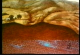
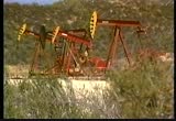
water has always been vital to civilization. cities and towns are usually built along an abundant supply of fresh water, such as a river or a lake. but lakes and rivers can't supply all the water we need, so we've tapped into another source--groundwater. the practice of water dowsing-- finding underground water using forked sticks-- has been going on for centuries. typically, the dowser grasps the fork of the stick and points the other end skyward. then, as he's walking along and happens to pass over a supply of underground water, the end of the stick, or divining rod, supposedly twists downward, showing where to dig the well. in reality, almost anywhere you popoint the stick, you'd eventually find water. although its depth varies considerably from place to place, water is present beneath the earth's surface almost everywhere, even under the driest deserts. most people tend to take groundwater for granted, but it's a tremendously valuable resource
9:02 am
upon which most of us depend. over 1/2 of the u.s. population relies on it for its drinking-water supply. even more groundwater's used for irrigating agriculture, and its industrial use is growing every day. groundwater is valuable because it's plentiful and clean. there's about 50 times more water underground than in all the lakes and rivers on the earth's surface combined. in many areas, especially those with dry climates, groundwater is the most abundant and economical source of water available. because it's filtered as it passes through the soil, groundwater is usually less polluted than surface water. but this valuable resource is now being threatened. in some places, groundwater has been contaminated by industrial or agricultural pollution. in others, wells extract groundwater faster than it can be replenished. already, this has caused severe economic and health problems in several areas of the world. consequently, there's an increasingly important role for the geologists who study water movement underground
9:03 am
and who can accurately predict the location and quantity of groundwater. "water, water everywhere, yet not a drop to drink." so went the complaint of the ancient mariner as he looked out over the salty brine. although the earth is sometimes referred to as the water planet, only a tiny fraction of this water is usable by human beings... and most of this fresh water comes not from above, but from beneath the earth's surface. this groundwater originates in various ways. water percolates continuously into the earth from lakes and rivers, for example. most important of all, however, is rainfall. [thunder] in some places, rain water readily disappears into the ground. of course, water doesn't get beneath the land surface
9:04 am
with equal ease everywhere on the globe. when it lands on hard bedrock or asphalt pavement, it simply runs off to feed nearby streams and rivers. but if there are cracks or fissures in the surface rock, the water can pass through to collect underground. even hard rocks, such as basalt or granite, usually have some fractures in them through which water can permeate. other land surfaces consist of less solid aggregates of material such as sandstone or sediment or ordinary soil. here the water can work its way down through the gaps, or interstices, between the individual bits of matter. although permeable rock will let the water through, it still may not be a good source of groundwater. for a rock to contain abundant groundwater,
9:05 am
it also needs to have a lot of open spaces, or pores. the capacity to transmit water is called permeability, and the capacity to store water is called porosity. the ideal rock material for the accumulation of groundwater is both porous and permeable. this kind of material is known as an aquifer-- from the latin for "water-bearing." sandstone is a good example of an aquifer. clay, on the other hand, is a material that tends to exclude the flow of groundwater. it is an aquiclude, the opposite of an aquifer. as clay absorbs liquid, its individual grains swell up while becoming saturated and close the channels between adjoining pores, thus blocking the passage of groundwater.
9:06 am
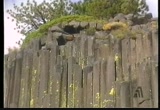
while groundwater has the effect of making clay layers swell, it can eat away other rock types. the most vivid example of this is the formation of caves. infiltrating groundwater is always slightly acidic because it has reacted with carbon dioxide in the air, thus forming carbonic acid. this acid gradually dissolves limestone, especially along joints. if the groundwater eventually drains off, it will leave behind air-filled caverns. columns of rock build up inside these caverns. these formations are created by droplets of groundwater seeping into the caves.
9:07 am

as each drop clings to the ceiling for a brief moment, enough evaporation takes place to precipitate a minute amount of calcium carbonate. over centuries, untold millions of such microscopic grains of rock will form stalactites above. and from the build-up of droplets that reach the floor below, stalagmites will form. in places where caves are still flooded, geologists can trace the flow of groundwater by releasing nontoxic dyes... that will ultimately reappear at the earth's surface in the form of springs and rivers. one reason geologists study groundwater
9:08 am

is to learn how it moves beneath the earth's surface. the area in which the water accumulates is known as the saturated zone, and the layer above it-- the unsaturated zone. when a well is dug into the saturated zone, the groundwater will fill the lower part of the well. the water level inside the well marks the upper surface of the saturated zone. this surface is called the water table. where the land surface is flat, the water table beneath it is also flat. but where the land is hilly, the water table will also have an irregular surface with high and low parts roughly corresponding to the overlying topography. in valleys, the zone of saturation may rise to meet the earth's surface at river and lake beds.
9:09 am
when the rivers and lakes are full, a continuous supply of new groundwater recharges the zone of saturation, and water flows from the surface into the ground. however, during the dry summer months when surface water levels are low, groundwater may flow in the opposite direction, providing the rivers and lakes with their only supply of water in the absence of rain. this phenomenon is called effluence. where groundwater flows out through an opening to the surface-- as, for example, along a joint or a fault-- springs form. most springs flow year-round, even through the long hot months of summer when they might be expected to dry up. this is because the water that comes out of the ground in the summer may well have started its journey the previous winter.
9:10 am

getting water out of the ground requires working against gravity and pumping the water up. but in some wells, the groundwater will move upward of its own accord in apparent defiance of gravity. these are called artesian wells. to understand how these valuable wells work, a classification of aquifers into two types-- open and closed-- is useful. in an open aquifer, a stratum of permeable rock overlies the water table, so that the pressure of the water-- in other words, the hydrostatic pressure-- at the top of the zone of saturation is quite low, too low for the water to rise up unassisted to the land surface. the other main type of aquifer, the closed aquifer,
9:11 am
is overlain by a layer of impermeable rock-- an aquiclude. where such an aquifer is inclined with its highest level exposed at the surface, water can enter directly into it in what is known as the recharge area. the weight of the water entering the inclined aquifer via the recharge area, combined with the confining effect of the layer of impermeable rock above, causes hydrostatic pressure to build up. if a well is dug in the appropriate place, this pressure is often strong enough to drive water up to the surface against the pull of gravity. one way to better understand how hydrostatic pressure can make water flow upward is to try a simple experiment with a hose.
9:12 am

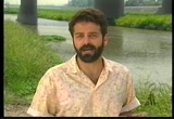
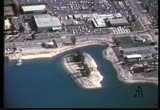
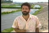
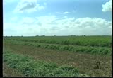
when water is poured into the higher end, its weight drives the water up and out the lower end of the hose, even though the lower end is above the sagging middle of the hose. one of the most significant aquifers in the united states lies just south of los angeles in orange county, where it supplies water for two million people. the total potential capacity of this aquifer is estimated at between 10 and 30 million acre-feet. this equals the total volume of water that lies beneath the entire state of california. this is all the more surprising because before its settlement, low rainfall made most of this region a virtual desert. the coastal plain of southern california, of which orange county is a part, is particularly well suited for, uh, groundwater storage. it has several things going for it.
9:13 am

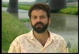
a--it's very deep, some 4,000 feet deep, uh, to, uh... all containing fresh water, of which we only use about the upper 1,500 feet. it has a, uh... surface water supply. it's the only perennial stream in southern california. the--this stream is fed by-- by snow melt in a very large mountain range behind us. again, in a desert area, we have snow that feeds a perennial river system which provides continuous water supply. another factor that helps out a great deal in maintaining the flow of the water down this river is the fact that we have considerable residential and commercial development upstream of us, which, uh, provides us waters of waste-water origin. that means the water
9:14 am
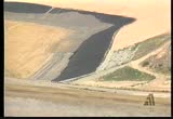
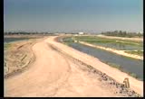
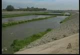
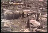
has gone through a treatment plant once upstream and has gone through a series of biological cleansing activity, which provides us with a very suitable supply of water to go into our groundwater basin. so we're blessed with very permeable soils, a very large storage capacity, and a steady supply of water. part of the success of the orange county water district can be traced to measures taken to recharge the local aquifer. one of the ways we manage the groundwater basin is by ensuring that we put as much water back into the ground as we take out through a se this is done through our recharge facilities, much like the one shown in the background. these recharge basins consist primarily of old gravel pits and also what's in the channel. the off-channel or old gravel pits capture water from the river and divert it into these basins
9:15 am
where it effectively percolates into the groundwater. all of these basins are underlined by porous, high-permeable sediments that are in connection with the underlying aquifers which extend down into the lower part of the basin. therefore, water is able to percolate through these basins into the aquifers and effectively recharge the whole orange county groundwater basin. groundwater management requires a great deal of care, not only because the water itself is so vital, but because a diminished supply could cause the ground above to subside, and this, in turn, could trigger a multitude of problems. as water infiltrates into an aquifer, the permeable rock soaks up the water like a sponge until it's saturated. the weight of this saturated zone generates an aquifer pressure that forces rock particles apart. this pressure also helps to hold up the ground surface,
9:16 am
even inflating it slightly. when groundwater is withdrawn, the pressure decreases, and the particles pack more tightly together. if the rate of water withdrawal exceeds the rate of infiltration, the overlying ground surface will often subside. ground subsidence can be dramatic and have disastrous consequences in areas of high groundwater withdrawal. in houston, texas, for example, 3 meters of subsidence has occurred over 40 years of overpumping, resulting in tens of millions of dollars of property damage and the loss of 80 square kilometers of land. one suburb, crystal cove, had to be abandoned completely because of flooding. in italy, groundwater withdrawal has caused the lean in the tower of pisa and contributes to continued flooding in the canal city of venice. sometimes, groundwater withdrawal can cause the ground to collapse like sand going through the neck of an hourglass, resulting in sinkholes like these. in other regions,
9:17 am
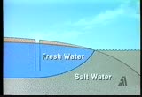
the surface of the earth is torn by giant cracks. in coastal regions, the excessive withdrawal of groundwater can cause other problems in addition to subsidence. beneath land, groundwater is fresh, but underneath the sea floor, it is salty. since fresh water is less dense than sea water, fresh groundwater just inland from the coast will tend to float on top of a salt water base. if fresh water is pumped out faster than it can be naturally replenished, sea water will flow in to replace it. as a result, the well water becomes increasingly salty, making it useless for drinking and poisonous for irrigation. other groundwater pollution problems also exist, involving contamination from many sources such as factories,
9:18 am

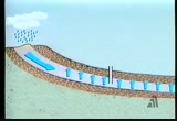
farms, septic tanks, garbage dumps, and less often, radioactive waste depositories. headlines like these about toxic drinking water have been all too common in recent years. one way in which we pollute groundwater is through badly designed or improperly maintained landfills. when rain leaches the pollutants from a landfill into the saturated zone, a plume of polluted waste spreads out in the direction of groundwater flow. fortunately, engineers are now developing more effective techniques to minimize the impact of landfills on groundwater quality. one of the techniques that has been developed is a landfill liner system. its multiple layers act as a barrier beeen the garbage and the surrounding environment.
9:19 am
the base of the liner system is simply a layer of impermeable clay which is spread around the landfill and compacted by heavy equipment. while the clay itself might be adequate to prevent the seepage of polluted water, or leachate, out of the landfill, extra precautions are taken. a synthetic, high-density plastic liner is placed on top of the clay. next, a half meter or so of permeable sand, along with drainage pipes, is laid across the plastic. here, the leachate accumulates and flows out from beneath the landfill for safe disposal elsewhere. at some landfills, the methane gas produced by decaying waste is collected and burned to generate electricity. and so, a composite landfill liner can serve a dual purpose--
9:20 am
protecting groundwater quality and providing an additional source of electricity. the great irony about groundwater is how little attention it often gets in discussions about dwindling resources. we worry about running out of oil, and there's no question it's of great importance to our global economy. but when all is said and done, life could go on, even without hydrocarbons. there are, after all, alternative sources of energy. but when it comes to water, there is no substitute. without water, life is simply not possible. fortunately, groundwater resources are not as limited or irreplaceable, for groundwater is more rapidly replenished by nature than is oil. but the time scale of natural replenishment
9:21 am
is very long, at least by human standards. at the current level of infiltration, it would take thousands of years to restore the water supply that has been pumped from beneath many cities in but a fraction of that time. in addition to ensuring adequate supply, protecting the quality of water is also of utmost importance. again, orange county is an excellent example of how geologists go about doing this. there are two aspects to water quality. first of all is-- we're in a coastal basin. we're next to the ocean. if we draw the basin down, salt water would flow in to take the fresh water's place and thus severely damage the basin. the other aspect is pollution. in the case of salt water intrusion, we have built injection wells along the coast,
9:22 am
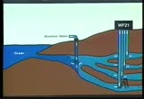
and we are either putting imported water in them, or we're putting reclaimed waste water that's produced at our water factory 21. the orange county injection wells act as a hydraulic barrier along the coast which keeps the salt water out even if the level of the groundwater in the basin is drastically lowered. in pollution, we have an industrial base in orange county and much of southern california. there is more circuit board manufacturing done per square mile in orange county than anyplace else in the world. so we have things that potentially could get into our groundwater basin-- solvents, heavy metals, et cetera, but we have a very detailed source control program that's managed by our sanitation districts here that don't allow discharges of that material
9:23 am
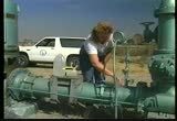
either into our basins or into the waste water stream that eventually gets into our injection barrier. because water quality is such a vital part of groundwater management, it is essential to monitor the water both above and below the surface. traditionally, we've sampled our groundwater basin at the production well, and we still do that because the next step is your faucet, and we're very concerned about what reaches the faucet. but it would also be nice to know if there is something coming down the aquifer that we don't know about and find it before it reaches the production well. so, what we've done at orange county is developed a very sophisticated groundwater monitoring program
9:24 am

which uses surface water sampling, production well sampling, and dedicated monitoring well sampling. our monitoring wells are drilled to a depth of about 1,500 feet and isolate and tap up to 18 zones that we can monitor individually, so that if a contaminant is coming towards us-- towards a production well-- we can find it before it becomes a problem and institute a mitigation. the monitoring wells provide a picture not only of when and where contamination is occurring, but also of the geological structure of the groundwater basin. as a well is drilled, samples of the rock are collected and analyzed. from these data, the substructure is mapped and computer models created to predict how groundwater flows through the basin.
9:25 am

this information is extremely important because it helps water district personnel plan how to effectively contain groundwater pollutants. we don't wait for regulatory agencies such as the state or the epa to come to us and tell us we've got a problem. it's too late then. we're looking at managing our own groundwater basin as though we had to drink the water, and we do. life demands water, and groundwater is an immensely important natural resource. groundwater is recharged by the infiltration of rain and snow and surface water into the fractures and pores in rocks. rocks that are both highly porous and permeable make the best-quality aquifers and will contain the most abundant groundwater supplies. aquifers are vital to the water supplies
9:26 am
of both cities and farms, but many are threatened by problems that need to be addressed now if these aquifers are to be used by future generations. they are in danger of being depleted not only by a rapidly rising demand for water, but also by wasteful water use practices. large-scale land subsidence is a dramatic reminder that the problem of overpumping has been poorly addressed in the past. aquifers are also in danger of pollution, a problem closely associated with our mounting waste disposal needs and also the increasing toxicity of our waste products. but the groundwater picture isn't as bleak as it may seem. in recent years, earth scientists have gained a much clearer view of how aquifers are maintained and the way that water behaves underground. this knowledge is being used to locate new aquifers and to develop strategies for dealing with groundwater-related problems. some aquifers are being recharged artificially. this protects water quality and prevents subsidence while assuring communities of an adequate water supply.
9:27 am

hydrogeologists using computer models are working to track and predict the movement of groundwater contamination and are actively involved in developing methods for isolating and removing contaminants from the groundwater directly. although the golden age of hydrogeology is well under way, there's still much work to be done. hydrogeologists will continue to play a critical role in maintaining groundwater resources not only for ourselves, but for future generations. captioning performed by the national captioning institute, inc. captions copyright 1991 the corporation for community college television


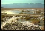
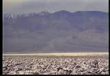
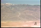
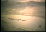
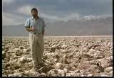
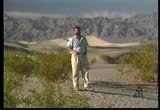
9:31 am
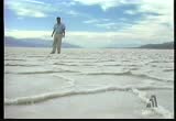
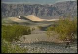
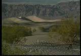
death valley hasn't always looked like this. within the last 100,000 years, a lake 600 feet deep covered this valley floor. the surrounding shoreline was grassland, and these hill slopes were covered with pine trees. the mild, relatively humid climate was enjoyed by such diverse animals as bison, antelope, horses, pelicans, and flamingos. all of this changed about 11,000 years ago. the earth's climate began to warm, and the glaciers of the last ice age melted back in retreat. today the lake is gone. it's been replaced by this salt-encrusted dry lake bed. when the lake disappeared, so did the grasses, and the forests retreated up the mountain slopes. a very different community of plants and animals now inhabit this region. in short, all of the characteristics of a typical desert. but death valley is not alone.
9:32 am
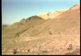
we see this same dramatic change in environment in deserts all over the world. this change is the direct result of geologic processes operating on a global scale. located primarily along the tropics of cancer and capricorn, deserts cover almost 1/4 of the earth's surface. most of us have a very limited, somewhat stereotypical picture in mind when we think of what a desert looks like. but the fact is that deserts can take many sometimes unexpected shapes and forms. if you ask most people, they would probably say a desert is a dry area with no vegetation, but this isn't a good definition for several reasons. there are many dry areas with no vegetation that you wouldn't think of as deserts. antarctica is an example. there's almost zero precipitation at the south pole. we can look at point barrow, alaska,
9:33 am
which receives only four or five inches of rain a year and has very little vegetation. yet the soil there is water sodden. there are ponds and lakes. it's hardly what you'd think of as a desert. on the other hand, some deserts have a great deal of vegetation. the mojave desert of eastern california has vast stands of giant yuccas-- the joshua trees. to develop a simple definition of a desert, we can find a common denominator in each of these harsh desert landscapes-- from the polar regions of antarctica and northern alaska to the vegetated sands of the mojave desert. deserts are regions with infrequent precipitation, averaging less tha 25 centimeters per year. in most deserts, evaporation rates are high enough to quickly remove this moisture.
9:34 am

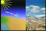
to understand the origin of the earth's hot subtropical deserts, the largest on the planet, we must first consider the equator. like the deserts themselves, the equator is a hot place, but it is also very humid, with torrential rain any time of year and steamy tropical rain forests. why are the tropics wet and the subtropics dry? as the earth orbits the sun from season to season, the sun always shines directly overhead somewhere in the tropical latitudes. therefore, the sun's rays strike the equator more directly than the rest of the globe. as the air heats up, water evaporates. the warm wet air rises, and as it rises, it expands and cools.
9:35 am

the vapor it contains condenses into clouds, many of which release rain. the cool air is now dry, but more and more warm air is rising up beneath it. this displaces the cool air away from the equator, pushing it north and south toward the subtropics. because of earth's spheroidal shape, air currents begin to crowd together as they move into higher latitudes. this causes the air to grow dense and heavy, so that it descends earthward about 30 degrees north and south of the equator. the air is compressively heated upon reaching low altitudes. the result is a mass of warm, dry air, few clouds, and low humidity. this encourages evaporation. the result is the stark, parched landscape
9:36 am

of most of the world's deserts. a few deserts occur outside these subtropical latitudes in the rain shadows of mountains, such as california's sierra nevada. the rain shadow effect works as follows. warm, moist air moves east across the pacific. it hits the coast and is forced upward to get over the mountains. as it rises, it expands and cools, and its moisture turns into clouds, rain, and sometimes snow. this leaves the air dry. as this cool, dry air moves down, on the leeward side of the mountains, it is compressed and heats up again. the air, now warm as well as dry, sucks up what little moisture may be available from the land below, creating deserts as it continues its journey
9:37 am

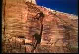
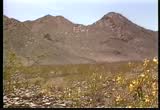
east of the sierra nevada. many of the world's most prominent or well-known deserts are the result of this rain shadow effect-- the mojave in the united states, the gobi desert in central asia. western south america has a similar situation. we have a chain of mountains down the west coast-- the andes-- which serve as a barrier forming this rain shadow. another factor that plays an indirect role in the formation of deserts is plate tectonics. the position of the continents in the polar regions or the equatorial regions or the subtropical regions, of course, is a function of plate tectonics. as an example, africa, 250 million years ago, in permian times, was much farther south, near the south pole. what we call the kalahari desert now was glaciated at that time. that wasn't long ago. that was only about 5% of geologic time.
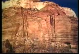
9:38 am
in the southwestern united states, too, there is evidence of a once widespread desert that existed 200 million years ago. fossil dunes are preserved in the upper wall of the grand canyon and in the sandstones of zion national park. the varied surfaces of the shifting sand dunes appear as crisscrossing sets of beds. their large size and coloration from the oxidation of iron show that they formed on dry land. since that time, plant and animal fossils indicate that this region became moist and forested. but in recent geologic time, conditions have become drier in response to plate motions, mountain building, and the development of rain shadows. some lands are deprived of moisture simply becausese they lie a great distance from the ocean, which is the primary source of moisture for rainfall. in western china, the gobi and the takla makan
9:39 am

are both locked deep inside a land mass. moist air masses precipitate most of their water before reaching these regions. the rain shadow effect of surrounding mountains is also a factor. a few deserts exist where cold marine water comes into contact with warm air next to a coastline. such conditions prevail along the coasts of northern chile and southwest africa. along the north coast of chile and the coast of southwest africa are deserts which extend all the way to the sea, and these deserts are quite unusual because they owe their existence to cold offshore marine currents. now, in many coastal latitudes, the air coming off the ocean is full of moisture which is evaporated from the sea, given ordinary sea surface temperatures. but these cold marine currents chill the overlying air
9:40 am
and so reduce its capacity for holding moisture. the air that blows inland, as a result, is very dry, and the result of that are these coastal deserts. so there are several ways by which deserts can come into being-- subtropical descent of equatorial air currents... rain shadow effects... great distance of land mass from the sea... cold coastal currents in warm latitudes... and in polar regions, the inability of cold air masses to hold much moisture. most of these extreme desert environments contain many unique land forms which, despite the infrequency of rainfall, are often shaped by running water. this seeming paradox can be explained by the fact that desert rainstorms,
9:41 am
while sporadic, are generally intense, creating flash floods. these brief, but violent episodes are highly erosive, quickly transporting enormous quantities of sediment and over time carving canyons. these floods also cause sediment to accumulate at the base of mountains in cone-shaped deposits called alluvial fans. the phenomenon of flash flooding in the desert raises the question of drainage. where does all the water go? drainage in deserts is characterized by internal drainage. it has a drainage pattern that isn't connected to the regional drainage pattern. only the largest rivers in the world-- the nile in north africa, the niger in west africa, and the colorado in the united states-- persist as they flow through deserts. most rivers or streams flowing into a desert will sink into the soil and disappear
9:42 am
or else collect in a pond or a salt lake. generally, desert streams disappear in deserts because of the high rate of evaporation and also because of the unconsolidated nature of the sand and sediment on the floor. a good example is the mojave desert in california, where there's only one stream-- the mojave river-- involved in the drainage pattern. it rises on the edge of the mojave in the san bernardino mountains, flows into the mojave, but mostly is underground. there's only three places where, in a normal year, it surfaces. in wet years, like 1969, '78, '80, and '83, it was above ground most of the way. in fact, it flowed over into soda lake and became an honest-to-goodness lake. although it plays the dominant role, running water isn't the only geologic agent shaping the desert landscape. most of the year, the desert surface is dry. this allows the wind to pick up
9:43 am

grains of sand and silt and move them. sand is relatively heavy. it's not carried far by the wind. it's deposited as dunes close to the source. on the other hand, silt is much lighter and finer grained. in a single storm, silt can be carried across entire continents or ocean basins. the airborne desert dust blown by the wind consists mainly of particles of rock and mineral grains. but as the wind stream continues around the globe, it also carries with it tiny fragments of plants and animals, ash from coal-fired electrical plants, other industrial detritus, and occasionally glassy volcanic ash. this flotsam and jetsam is shuffled and sifted through the atmosphere, storm after storm, until there's hardly a square meter of the earth's surface
9:44 am
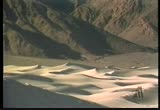
that does not contain material blown in at sometime from somewhere else. some of this windblown dust can be a blessing. the soil of the midwestern united states owes much of its fertility to what geologists call loess. loess is made up of fine particles of silt and clay that have drifted in over the millennia from barren lands uncovered by melting pleistocene ice. in eastern china, deposits of loess have reached remarkable proportions, hundreds of meters thick. from time immemorial, the chinese have carved cave dwellings out of this soft, but surprisingly cohesive material. windblown sand, too heavy to blow across oceans and continents, bounces and skips along the ground
9:45 am

until it is caught by an obstacle in its path. here it begins to accumulate, forming an even larger trap for additional sand. wind plucks sand from the windward side of the dune, blowing it across the crest, where it settles on the quiet leeward side. in time, the entire dune shifts downwind, grain by grain, possibly migrating kilometers from its point of origin. a major source of desert sand is desert playas-- lake beds from more humid times which have long been dry. the same winds that build up dunes may also hollow out depressions in the land surface. these dish-shaped hollows are called blowouts. sometimes wind can be channeled uh, in narrow streams. uh, in parts of the sahara desert, this is happening, for example,
9:46 am

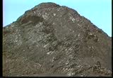
between long rows of parallel dunes. uh, where this wind is concentrated against the earth's surface, it can blow away vegetation, and through time, uh, bit by bit, carry away the loose, uh, soil and sediment present at the earth's surface as well. under certain extreme circumstances, so much material may be removed that the top of the water table is exposed. this provides for creation of an oasis. these aren't common in most parts of the world, but do occur in some of the larger deserts. more commonly seen than blowouts is what's known as desert pavement. as the wind blows away silt and particles of dust, eventually, only heavy chips of rock and gravel are left behind. over thousands of years, this rocky waste
9:47 am
accumulates as a layer of stones resembling a pavement which protects the land from further erosion. but desert pavement is extremely fragile and easily damaged. many outcrops, as well as desert stones, are also covered with desert varnish-- a thin, shiny coating on the rocks that increases with age. the varnish is composed of dark manganese oxide and clays. one explanation for the formation of this feature involves weathering, evaporation, and precipitation. this varnish forms over rock surfaces throughout the desert as a result of, um, acid weathering, chemical weathering, uh, during periods of rainfall or heavy moisture, winter moisture. uh, obviously this water can't travel very far before it evaporates
9:48 am
because of the dry desert conditions so it precipitates a residue of dissolved mineral constituents as a thin film across the rocky surface over which it's flowing. hence, the buildup over time of these manganese oxides. windblown clay grains adhering to rock surfaces may assist varnish formation by soaking up moisture from adjoining soil. microbes could also play a role in producing varnish through complex biological processes. desert varnish can be 2,000 years in the making-- providing a writing surface for rock inscriptions from ancient cultures. the desert, like any environment on earth, is a result of a critical balance
9:49 am
of geologic conditions. climate, topography, and plate tectonics interact to determine whether an area will be, say, a desert or a forest or a prairie grassland. human activity, however, is capable of disrupting this natural balance triggering a chain of events that can cause desert to invade a nondesert region. this process called desertification can be frighteningly rapid and its consequences staggering. consider a fertile spot like this. its most obvious characteristic is its color--green. the green color arises because the vegetation absorbs the sun's energy in all wavelengths except that of the color green. this absorption of energy means there is less heat available to warm the overlying air.
9:50 am
so the air is cooler and more likely to produce rain. the chance of rain is further increased by the fact that the vegetation is an important source of water vapor, released to the air through leaves. if great amounts of vegetation are destroyed as land is developed or overgrazed, the bare earth may be exposed, reflecting heat back into the atmosphere. if there are no trees or plants to store heat and release moisture, the air gets warmer and drier, and there's less chance of rain. with no tree or plant cover for anchorage, the topsoil can erode rapidly, discouraging new plants from taking root. if the region lies in a semi-arid climate or near the margin of a desert,
9:51 am
this destruction of soil and vegetation may convert it into new desert. this change may be permanent for all practical purposes. for once desertification starts, it takes a costly effort to stop. in the united states, the most dramatic example of desertification occurred on the great plains. there had always been a very delicate ecological balance in this region between the very slight rainfall and the fragile plant life. when ranchers started overgrazing the land and farmers began overworking the soil, the situation became extremely dangerous. all it took was the great drought of the 1930s to turn the plains into a raging dust bowl.
9:52 am

fortunately, thanks to conservation efforts and a series of wet years in the 1940s, the wheat lands of the great plains were eventually saved from becoming a desert. it remains to be seen whether the result of more recent and even more catastrophic desertification in africa can ever be reversed. this is the sahel-- a semi-arid region to the south of the sahara desert. in the 1960s, a series of abnormally rainy years encouraged farmers to expand their herds and grazing lands. then in the early 1970s, there was a terrible drought. the plant life of the region was virtually wiped out. some 40% of the cattle died. by the 1980s, continuing drought had completely denuded the soil,
9:53 am

creating choking dust storms and migrating dune fields. the desert was creeping into formerly verdant areas at an average rate of 10 to 15 meters a day, destroying the livelihoods of over 20 million people. more than 100,000 starved to death. the suffering was particularly acute in ethiopia and the sudan. the sad irony is that modern technology helped to magnify the disaster. prior to the drought, deep water wells had been drilled in the sahel, providing abundant new sources of water for livestock and humans. this stimulated an excessively large migration into the area. so when the drought struck, there was even greater devastation.
9:54 am

numerous international programs are currently underway to teach people how to graze their cattle and grow their crops so as to avoid similar disasters in the future. there are a number of techniques being employed to prevent desertification. water conservation techniques-- again, one of the primary causes of desertification is the depletion of ground water reserves-- and also intelligent farming techniques. for example, if you move into an area and deforest it, remove the vegetation and then plow it, particularly in an area like the subtropics where you have the prevailing winds, you can lose your topsoil. so intelligent farming techniques-- for example, those that don't remove all the trees, those that don't necessarily plow the ground or plow it deeply-- are being tested in africa, for example,
9:55 am
and have been quite successful. the yield the first several years of farming is less, but on the long run, you don't destroy the soil. you don't remove the topsoil. you don't pollute the streams from pesticides and fertilizers. so, there is hope. while human activity can influence the expansion of arid lands on a short-term basis, more powerful geological forces are at work to change the shapes of deserts over long periods of time. global climate changes, still poorly understood, have caused the edges of the earth's deserts to shift by hundreds of kilometers over the past few million years. 18,000 years ago, for example, the deserts of africa were much smaller than they are today. but while the size of the world's deserts
9:56 am
has fluctuated throughout history, one factor has remained constant-- deserts have always been regarded as hostile, extreme environments. as a result, we have tended to overlook the great beauty, wonder, and potential value of these unique regions. there is more to the desert than geologic processes. deserts have a surreal quality that has captured the human imagination throughout the ages. perhaps this is because deserts are places of extremes, of contrast. this stark, seemingly lifeless expanse of bare rock and sand is actually home to a rich assemblage of life forms. the blinding white of dune sand and playa salt stands in sharp contrast to rock surfaces blackened by desert varnish. the searing, hot desert day is followed by the refreshingly cool, sometimes frigid, desert night. but in spite of the fact that the desert is a harsh environment, it's also a fragile one.
9:57 am
it deserves our respect. but in return, we and those who follow us can continue to enjoy its beckoning vistas, its clean and rugged beauty, and its diverse assemblage of life forms and land forms until the climate pendulum swings back and transforms the desert into lake or grassland or forest once again. captioning performed by the national captioning institute, inc. captions copyright 1991 the corporation for community college television
9:59 am

inactive activities on a glorious day! huh? let's get out there and play! yeah! sweet. whew! p-l-a-y! play! there are lots of great play ideas online.
190 Views
IN COLLECTIONS
LinkTV Television Archive
  Television Archive News Search Service
Uploaded by TV Archive on
